


VANCOUVER, British Columbia, Feb. 27, 2025 (GLOBE NEWSWIRE) -- Entrée Resources Ltd. (TSX:ETG; OTCQB:ERLFF - the "Company” or "Entrée”) is pleased to provide analytical results for eleven underground diamond drill holes ("DDH”) completed in 2022 - 2024 at the Hugo North Extension ("HNE”) deposit on the Entrée/Oyu Tolgoi joint venture property (the "Entrée/Oyu Tolgoi JV Property”) in Mongolia. Analytical results are also provided for one DDH completed at the western edge of the Heruga copper-gold-molybdenum deposit and five DDH from the 2024 regional drilling campaign.
One underground DDH from the 2023 drilling program at HNE, two surface DDH and eight underground DDH from the 2024 drilling program at HNE, and two 2024 regional DDH are pending analytical results. These results will be reported as they become available from the Company's joint venture partner Oyu Tolgoi LLC ("OTLLC”).
DRILL HOLE HIGHLIGHTS
HNE Underground Drill Holes
- UGD 578: 164 m grading 1.61% copper equivalent ("CuEq”), including 72 metres ("m”) grading 2.89% CuEq.
- UGD 807C: 465.5 m grading 1.51% CuEq, including 188.5 m grading 2.50% CuEq.
- UGD 815: 224 m grading 2.05% CuEq.
- UGD 852: 351.2 m grading 1.53% CuEq, including 104 m grading 2.65% CuEq.
- EJD0099: 409.9 m grading 0.58% CuEq, including 230 m grading 0.79% CuEq.
Note: Copper equivalent for HNE and Heruga are defined below Table 1, where full details on the drill hole assay intervals are also found.
HNE DRILLING RESULTS
The new drill hole analytical results from the HNE deposit include eleven underground DDH completed during 2022, 2023, and 2024 (Table 1). This includes drill hole UGD 578 from 2022 that was previously classified by OTLLC as a geotechnical hole that would not be analyzed. Four underground DDH from 2023 and six underground DDH from 2024 are also reported. These holes were all collared from existing infrastructure on the Oyu Tolgoi mining licence and drilled to the north or northwest onto the Entrée/Oyu Tolgoi JV Property, targeting mineralization within the existing footprint of the HNE deposit.
OTLLC has informed Entrée that three of the 2023 surface drill holes (EGD175, EGD176 and EGD182) that were noted by the Company on July 18, 2024 as "pending analytical results” will not be assayed since they were used purely for geotechnical and metallurgical purposes or were abandoned prior to reaching the target depth. A total of two surface DDH and eight underground DDH from the 2024 drilling program at HNE are still pending analytical results and will be reported as they become available from OTLLC.
Mineralized intervals from the eleven DDH at HNE recently made available by OTLLC are summarized in Table 1 and are shown on Figure 1.
Table 1: Underground Drill Results from 2022, 2023, and 2024 Drilling at the HNE Deposit1
| Drill Hole | Year | From (m) | To
(m) | Length2
(m) | Copper (%) | Gold (ppm) | Silver
(ppm) | CuEq3 (%) |
| UGD578 | 2022 | 150 | 314 | 164 | 1.36 | 0.42 | 3.25 | 1.61 |
| Including | 206 | 278 | 72 | 2.42 | 0.80 | 5.89 | 2.89 | |
| UGD807C | 2023 | 205.1 | 661.6 | 456.5 | 1.19 | 0.56 | 3.16 | 1.51 |
| including | 420 | 608.5 | 188.5 | 1.95 | 0.94 | 5.23 | 2.50 | |
| UGD812 | 2023 | no | significant | assays | ||||
| UGD815 | 2023 | 298 | 522 | 224 | 1.75 | 0.50 | 4.50 | 2.05 |
| UGD816 | 2023 | 293.1 | 421.3 | 128.2 | 1.63 | 0.24 | 4.18 | 1.79 |
| UGD806 | 2024 | 111.2 | 522 | 410.8 | 1.18 | 0.20 | 2.86 | 1.31 |
| including | 210 | 500 | 290 | 1.38 | 0.22 | 3.29 | 1.53 | |
| UGD811A | 2024 | no | significant | assays | ||||
| UGD852 | 2024 | 125 | 476.2 | 351.2 | 1.31 | 0.36 | 4.03 | 1.53 |
| including | 368 | 476.2 | 104 | 2.06 | 1.01 | 7.22 | 2.65 | |
| UGD853 | 2024 | 92 | 426.3 | 334.3 | 0.70 | 0.13 | 2.19 | 0.79 |
| including | 322 | 426.3 | 104.3 | 0.89 | 0.33 | 4.45 | 1.10 | |
| UGD855A | 2024 | 420.1 | 484.2 | 64.1 | 1.16 | 0.29 | 4.30 | 1.35 |
| UGD855B | 2024 | 424.2 | 428.7 | 4.5 | 0.44 | 0.11 | 1.09 | 0.51 |
- Analytical results are length weighted averages, only for the portions of the drill holes on the Entrée/Oyu Tolgoi JV Property.
- Lengths reported are drilled lengths. Approximate true widths are variable depending on the orientation of the drill hole. Several of the holes are geotechnical holes drilled subparallel to the trend of the porphyry. Other holes are drilled across the trend of the porphyry at varying orientations with estimated true widths ranging between approximately 20% and 70% of the drilled lengths.
- CuEq at HNE is calculated by the formula CuEq = Cu + ((Au * 35.7175) + (Ag * 0.5773)) / 67.9023, taking into account differentials between metallurgical performance and price for copper, gold and silver. Metal prices used are US$3.08/lb Cu, US$1,292.00/oz Au, and US$19.00/oz Ag. Metallurgical recoveries used are 82% for copper, 73% for gold and 78% for silver.
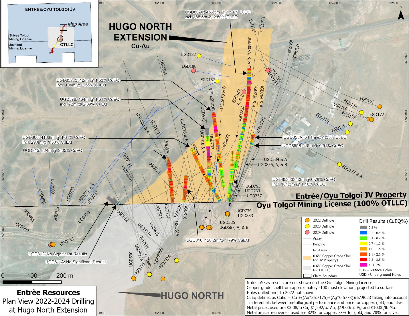
Eight of the ten 2023/2024 underground DDH with newly reported significant assays were drilled at moderate dips towards the north or northwest and after crossing onto the Entrée/Oyu Tolgoi JV Property intersected significant grades of copper and gold within the potential Lift 2 footprint of HNE. Drill holes UGD811A and 812 both reported no significant results; however, these holes had intersected the mineralized footprint on the Oyu Tolgoi mining licence, prior to crossing onto the Entrée/Oyu Tolgoi JV Property. Drill hole UGD578 (from 2022) was drilled horizontally towards the north, targeting the base of Lift 1, for geotechnical purposes, and intersected a wide interval of significant copper and gold mineralization.
The holes drilled into the mineralized porphyry intersected predominantly phyllic and potassic altered quartz monzodiorite, cut by occasional intervals of unmineralized biotite-granodiorite dikes (generally less than 10 m in drilled width). Total sulphide content is variable but averages around 5% and is comprised of a mix of chalcopyrite, bornite and pyrite hosted in quartz stockworks and disseminated form. Some of the highest-grade individual assays (grading around 5% to 10% CuEq) are often hosted within hydrothermal breccias, containing a majority of disseminated and coarse bornite and chalcopyrite.
2024 HNE DRILLING INFORMATION
The 2024 in-fill diamond drilling program at HNE included seven surface holes and 25 underground holes. As at January 27, 2025, a total of 4,652.1 m of surface drilling had been completed and 6,221.1 m of underground drilling had been completed on the Entrée/Oyu Tolgoi JV Property.
The 2024 underground holes were all collared from existing infrastructure on the Oyu Tolgoi mining licence and crossed onto the Entrée/Oyu Tolgoi JV Property. Several of the holes were drilled as "daughter holes” (wedges) from a "parent hole” at varying distances along the hole. Underground holes were designed to achieve multiple objectives; as in-fill holes within the mineralized footprint of Lift 2 to support the next mineral resource estimate update; for geotechnical purposes with many holes drilled outside of (west of) the mineralized footprint; and for metallurgical purposes.
All seven 2024 surface holes were collared vertically above, or just west of the mineralized footprint of HNE and drilled subvertically, or steeply to the east targeting Lift 2, or for geotechnical purposes. Three of the holes (EGD188, 190, 194) encountered drilling difficulties and did not reach the target depth, while two holes (EGD189, 189A) were drilled outside of the HNE footprint for geotechnical purposes. Drill holes EDG189B and EDG195 were drilled almost vertically through the northern portion of the HNE deposit and continued for almost 200 m below the base of Lift 2. Analytical results for the latter two surface holes are still pending.
Ten of the 2024 underground drill holes, denoted in Table 3 as having "no sampling”, were drilled from underground drill stations on the Oyu Tolgoi mining licence to the west of the mineralized footprint and were drilled mainly for geotechnical purposes to support infrastructure development.
Tables 2 and 3 summarize the drill hole details for 2024 HNE surface and underground drilling, respectively, and Figure 1 shows the locations of the 2022-2024 HNE drill holes and the significant assay intervals discussed in this press release.
Table 2: HNE 2024 Surface Drilling
| Drill Hole | UTM EAST | UTM NORTH | Elevation (masl) | Length (m) | Azimuth (degrees) | Dip (degrees) | Assay Status |
| EGD188 | 652119.1 | 4768556 | 1172.885 | 1,012.4 | 101 | -83 | No sampling |
| EGD189 | 652291.1 | 4768484 | 1173.33 | 730.3 | 4 | -89 | No sampling |
| EGD189A | 652291.1 | 4768484 | 1173.33 | 712.3 | 37 | -87 | No sampling |
| EGD189B | 652291.1 | 4768484 | 1173.33 | 598.4 | 44 | -85 | Pending |
| EGD190 | 652376 | 4768559 | 1179 | 525.9 | 320 | -86 | No sampling |
| EGD194 | 652372 | 4768557 | 1178.99 | 30.9 | 334 | -85 | No sampling |
| EGD195 | 652372.2 | 4768557 | 1178.99 | 1041.9 | 332 | -87 | Pending |
| Total Surface | 4652.1 |
Table 3: HNE 2024 Underground Drilling1
| Drill Hole | UTM EAST | UTM NORTH | Elevation (masl) | Length2 (m) | Length JV Property2 (m) | Azimuth (degrees) | Dip (degrees) | Assay Status | |
| UGD806 | 652234.7 | 4768067 | -76.31 | 522 | 425.6 | 330 | -60 | Complete | |
| UGD811A | 652059.3 | 4767907 | -80.8141 | 342.5 | 46.8 | 318 | -57 | Complete | |
| UGD852 | 652233.7 | 4768068 | -76.198 | 476.5 | 420.3 | 352 | -44 | Complete | |
| UGD852A | 652233.7 | 4768068 | -76.198 | 4.4 | 4.4 | 352 | -43 | Complete | |
| UGD853 | 652234.6 | 4768066 | -76.405 | 426.3 | 334.8 | 6.5 | -62 | Complete | |
| UGD855 | 652236.1 | 4768066 | -76.22 | 473.7 | 393.3 | 20 | -55 | Pending | |
| UGD855A | 652236.1 | 4768066 | -76.22 | 64.1 | 64.1 | 20 | -55 | Complete | |
| UGD855B | 652236.1 | 4768066 | -76.22 | 4.5 | 4.5 | 20 | -55 | Complete | |
| UGD871 | 651968.5 | 4767859 | -180.585 | 555.5 | 198.9 | 28 | -37 | Pending | |
| UGD872 | 651968.5 | 4767859 | -180.604 | 600 | 194.7 | 27 | -45 | Pending | |
| UGD873A | 651969.5 | 4767859 | -180.667 | 562.5 | 280.7 | 38 | -33 | Pending | |
| UGD876 | 652060.8 | 4767908 | -80.055 | 461 | 237.5 | 355 | -27 | Pending | |
| UGD881 | 650757.6 | 4768019 | -50.805 | 635 | 541.0 | 333 | -48 | No sampling | |
| UGD882 | 650757.2 | 4768018 | -50.727 | 748 | 620.3 | 302 | -35 | No sampling | |
| UGD883 | 650755.8 | 4768019 | -51.725 | 941.8 | 808.9 | 294 | -19 | No sampling | |
| UGD884 | 650756.4 | 4768019 | -51.77 | 750 | 405.2 | 279 | -25 | No sampling | |
| UGD894 | 651631.2 | 4767960 | -127.278 | 308 | 43.8 | 295 | 11 | No sampling | |
| UGD895 | 651631.1 | 4767961 | -126.75 | 271 | 92.6 | 319 | 16 | No sampling | |
| UGD896 | 651635.8 | 4767964 | -127.875 | 266 | 130.8 | 346 | 0 | No sampling | |
| UGD909 | 651635.5 | 4767964 | -128.053 | 291 | 158.8 | 360 | -5 | No sampling | |
| UGD915 | 651637.9 | 4767963 | -128.306 | 288.1 | 152.2 | 10 | -5 | No sampling | |
| UGD917A | 651967.2 | 4767862 | -180.531 | 418.6 | 41.0 | 343 | -50 | Pending | |
| UGD918 | 651968.9 | 4767861 | -180.214 | 449.7 | 65.7 | 35 | -40 | Pending | |
| UGD918A | 651968.9 | 4767861 | -180.214 | 67.6 | 67.6 | 35 | -40 | Pending | |
| UGD923 | 650762.7 | 4768019 | -51.77 | 589.4 | 487.6 | 33 | -47 | No sampling | |
| Total Underground JV Property | 6,221.1 | ||||||||
- Holes UGD881 to 884, 894 to 896, 909, 915, and 923 were drilled outside of the mineralized footprint for geotechnical purposes; azimuth and dip information is approximate, taken from down-hole survey results, generally at about 0-30 m from the collar of the hole.